The “Motif: an open-source R tool for pattern-based spatial analysis” article by Jakub Nowosad, published in Landscape Ecology, presents a related set of methods for spatial search, change detection, and clustering of areas with similar spatial patterns. This study developed new software and then applied it to four distinct examples. The created methods have a wide range of applications, including land management, environmental protection, and environmental change monitoring.
The natural environment is a complex system of interactions between living organisms, climate, and natural resources, interplaying with human activities. Registering, describing, and understanding these complex relationships on a global scale is a challenging task. Currently, we rely on remote sensing data, such as from sensors mounted on artificial satellites, for this purpose. However, such datasets are characterized by both a significant volume and a wide variety of stored information, making it beyond the capacity of individuals to analyze and take appropriate action based on the data. To meet this challenge, methods and computer tools are being developed to work with diverse data about the world around us.
The publication “Motif: an open-source R tool for pattern-based spatial analysis” describes the creation of a system for spatial analysis based on spatial patterns. This system uses processed satellite data (e.g., land cover data) to allow spatial searches, change detection, and clustering of similar areas. The designed analytical system has also been implemented as an open source software motif, which allows calculations on continental or global-scale high-resolution data.
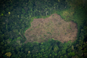
The new analytical system was applied to four case studies. Using New Guinea land cover data as an example, the first case study showed how one can mathematically describe diverse local areas. The second case study made it possible to find areas with similar topography to the Suwalki Landscape Park area. Using the developed methodology, it was determined that the most similar areas form a belt with homogeneous topography in northern Poland. The third case study showed a general overview of land cover changes for the Amazon region from 1992 to 2018, identifying the areas of most significant change in the southern and eastern parts of the region. Regions covered in 1992 mainly by forests are now largely replaced by extensive agricultural areas. The last case study delineated homogeneous regions in Africa with a similar arrangement of land cover and landforms.
The presented methods have a high degree of generalizability and should be widely applied in many fields, including land management, environmental protection, monitoring of forest cover changes, and urban development.