Szuman, I., Kalita, J. Z., Ewertowski, M. W., Clark, C. D., Livingstone, S. J., and Kasprzak, L.: GIS dataset: geomorphological record of terrestrial-terminating ice streams, southern sector of the Baltic Ice Stream Complex, last Scandinavian Ice Sheet, Poland, Earth Syst. Sci. Data, 13, 4635–4651. 2021
The landscape of north west Poland seem to be monotonous and undiversified. However, it gains a brand new sight when taking a closer look at it especially when the look is from several directions. For such a purpose three dimensional digital elevation model can be of a use. For several years data from airborne laser scanning have been available. The data allowed for detailed recognition of glacial landforms that have been formed about 20 000 years ago and have been of an interest for many researchers since beginning of XX century.
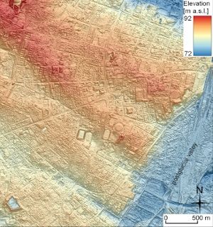
Within the project Reconstruction of glacial history in central west Poland during the Weichselian glaciation, the area of 65 000 km2 was analysed with one pixel on map corresponding to area of 40x40 cm in terrain. The results comprise dataset of 5461 individual glacial landforms or landform parts. The dataset is freely accessible here. The sample mega-scale glacial lineations from the attached figure are those upon which the city of Poznań is built.
These features constitute a valuable data source for reconstructing and modelling the last Scandinavian Ice Sheet extent and dynamics including ice streams that are responsible for rapid drainage of ice from ice sheets interior towards the margins. Since the observational timescale for Antarctic and Greenland ice sheets is short (decades), and it is a challenge to access their beds, the presented dataset provide a critical long-term constraint for testing and calibrating ice sheet models. It provides base for quantifying the sensitivity of ice sheets to climate change and future predictions of ice sheet mass loss and sea level rise.