An international group of scientists, led by Dr Izabela Szuman from the Department of Geomorphology at the Faculty of Geographical and Geological Sciences, Adam Mickiewicz University (AMU), worked as geo-detectives for several years, conducting an “investigation” aimed at explaining the behaviour of ice masses advancing into the Wielkopolska region. The results of their research were published in journal Boreas: Szuman I., Kalita JZ., Ewertowski MW., Clark CD., Livingstone SJ., 2021. Dynamics of the last Scandinavian Ice Sheet’s southernmost sector revealed by the pattern of ice streams. Boreas, 50(3):764-780 https://doi.org/10.1111/bor.12512
The landscape of the till plains in Wielkopolska is rather monotonous. While driving through this part of Poland, we can see gently undulating agricultural and forested terrain through the windows. The most significant variations are glacial troughs and sequences of more prominent hills, traditionally associated with the main retreat phases of the Vistula glaciation.
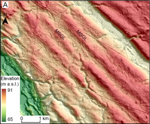
In the 20th century, the scientific debate primarily focused on the character of the ice sheet retreat. Advocates of two main hypotheses, areal and frontal deglaciation, were in conflict. For a long time, relatively little was known about the dynamics of the ice sheet during its advance towards this part of Poland. Only in recent years, with access to very detailed elevation data from airborne laser scanning (LiDAR), was it possible to create a three-dimensional digital terrain model. These data allowed the recognition of landforms created beneath the glacier, such as mega-scale glacial lineations.
As clues and evidence in their geo-detective investigation, the scientists used over 900 glacial lineations (streamlined bedforms) that formed due to the moulding of the terrain by rapidly moving ice masses. These forms range from 200 to 9000 meters in length, but they are difficult to observe from the ground due to their relatively small height (typically between 1.6 and 4.5 meters above the surrounding terrain) and gentle slope. Only analysing the detailed terrain model allowed the recognition of their distribution. The researchers connected various glacial forms like over 20,000-year-old puzzles and, based on this, identified 17 individual ice streams that, at different times and with varying activity, shaped the relief of Wielkopolska. The new reconstruction presented in the article indicates the asynchronous behaviour of ice masses during the last local glacial maximum and temporally and spatially diverse characteristics of recession. The work, published in the journal Boreas, can be read at: https://doi.org/10.1111/bor.12512
Text: Izabela Szuman and Marek Ewertowski

